 Released
 Dataset
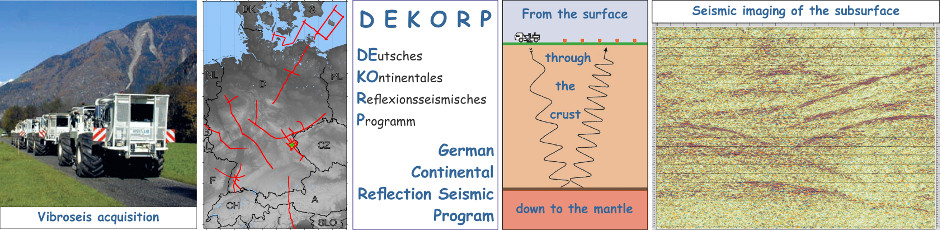
Reprocessed southern part of the deep seismic reflection profile DEKORP 1986-2N across the Rhenish Massif in the state of Hesse, Germany
Cite as:
Homuth, Benjamin; Stiller, Manfred (2022): Reprocessed southern part of the deep seismic reflection profile DEKORP 1986-2N across the Rhenish Massif in the state of Hesse, Germany. GFZ Data Services. https://doi.org/10.5880/GFZ.DEKORP-2N.002Status
I N R E V I E W : Homuth, Benjamin; Stiller, Manfred (2022): Reprocessed southern part of the deep seismic reflection profile DEKORP 1986-2N across the Rhenish Massif in the state of Hesse, Germany. GFZ Data Services. https://doi.org/10.5880/GFZ.DEKORP-2N.002 Abstract
The profile 2N was recorded in 1986 as part of the DEKORP project, the German deep seismic reflection program. The focus of the DEKORP project was on deep crustal and lithospheric structures and therefore originally not on structures at shallower depths. From today's perspective, however, this depth range is of great interest for a wide range of possible technical applications (including medium-depth and deep geothermal projects). The original data is published by Stiller et al. (2021). The southernmost 68 km of the 219 km long profile 2N were reprocessed on behalf of the Hessian Agency of Nature Conservation, Environment and Geology (HLNUG). The focus of the reprocessing was on improving the resolution / mapping of geological structures down to a depth of 6 km (approx. 3 s TWT) to describe the prolongation of faults and geological structures in more detail than in previous studies. In order to achieve these goals and in view of the fact that today's processing and evaluation methods have been improved considerably compared to the 1990‘s, a state-of-the-art reprocessing was implemented. In comparison with the original processing (Stiller et al. (2021)), more sophisticated processing steps like CRS (Common Reflection Surface) instead of CDP (Common Depth Point) stacking, turning-ray tomography and prestack time and depth migration were carried out.
The reprocessing results of the DEKORP 2N survey comprise all datasets newly achieved in addition to the datasets from the original processing (Stiller et al. (2021)), i.e. (1) the migrated CRS image gathers as unstacked data, and (2) the pure CRS stack, the poststack-time as well as prestack-time and prestack-depth migrated sections as stacked data. Moreover, (3) all velocity models used for the different versions including (4) the separate first-break tomography inversion, are contained.
All reprocessed data come in SEGY trace format, the final sections additionally in PDF graphic format. A reprocessing report is included as well as again all meta information for each domain (source, receiver, CDP) like coordinates, elevations, locations and static corrections combined in ASCII-tables for geometry assignment purposes.
The DEKORP 2 survey, consisting of the three segments 86-2Q, 86-2N and 84-2S, starts in the sub-Variscan foredeep of the Münsterland Basin and ends in the Moldanubian region at the Danube. The central part crosses the Rhenish Massif (Rhenohercynian), the Spessart Mountains of the Mid-German Crystalline High (Saxothuringian) and the meteorite impact location of the "Nördlinger Ries". The 219 km long, SSE-NNW striking DEKORP 2N line provides a cross-section through the Rhenish Massif from the sub-Variscan Münsterland Basin in the north to the Rhenohercynian Taunus Mountains in the south. The profile is the northern continuation of DEKORP 2S, which intersects at profile km 7.72. The reprocessed datasets contain a sub-section of the entire 2N with a total length of 67.84 km of full CDP fold, covering the profile’s southern part through the state of Hesse.
The DEKORP '86-2N profile is of particular interest to investigate the seismic resolution of the Rhenish Massif and its different structures, such as the Siegen anticline, the Dill syncline, and the Lahn anticline. In the most southern part, the profile reaches into the Rhenohercynian Taunus Mountains until the Taunus ridge.
The seismic sections of 2N show clear, deep reaching reflections along the prolongation of the whole profile supporting newer theories of nappe structures in the hessian part of the Rhenish Massif. The reflections are more clearly visible than in the original processing. All visible structures are mainly SE-dipping reflections in the upper crust, which represent lithologic contrasts as well as thrust faults known from surface geology. In the lower crust highly reflective predominantly SE-dipping reflectors can be identified. Moho reflections are clearly identifiable and deepening to the NW.
Additional Information
The German Continental Seismic Reflection Program DEKORP (DEutsches KOntinentales Reflexionsseismisches Programm) was carried out between 1984 - 1997 and funded by the Federal Ministry of Education, Science and Technology (BMFT), now Federal Ministry of Education and Science (BMBF). The data was originally processed in the DEKORP Processing Centre (DPC) at the Institute of Geophysics of the Technical University Clausthal. DEKORP was founded in 1983 with the aim to investigate the deep crustal structure of Germany with high-resolution near-vertical incidence seismic methods. It was closely associated with the deep drilling project KTB (German continental deep-drilling program). One of the main research topics of DEKORP were deep seismic studies to investigate the lithospheric structure beneath Germany. The DEKORP profiles cover approx. 450 km in the state of Hesse and mostly cross areas for which there is only insufficient geological data (i.e. only few deep boreholes).As a governmental agency the HLNUG archives and publishes the data for future applications and usages, such as the search for a repository for nuclear waste in Germany, an expansion of the geophysical database, possibilities for modelling using gravimetric and magnetic data as well as an improvement of the 3D underground model of the state of Hesse. Therefore, the results are directly linked to the new geological 3D model of the state of Hesse, developed by the Technical University of Darmstadt (Hessen3D 2.0 project, BMWi-FKZ: 0325944).
The reprocessed DEKORP datasets provide up-to-date unique and deep insights into the subsurface below Germany covering the earth’s crust from the surface to the upper mantle. Fields of applications are geothermal development, hazard analysis, hydrocarbon/shale gas exploration, underground gas storage, tunnel construction and much more.
Authors
Contact
- Stiller, Manfred; GFZ German Research Centre for Geosciences, Potsdam, Germany; ➦
- Homuth, Benjamin; HLNUG Hessian Agency of Nature Conservation, Environment and Geology, Wiesbaden, Germany; ➦
Contributors
Agafonova, Tatiana; Kaerger, LaurettaKeywords
Reprocessing, CRS, prestack depth migration, deep crustal structure, crustal-scale seismic survey, near-vertical incidence seismic reflection, Vibroseis acquisition, Rhenish Massif, Variscan orogenic belts, Taunus, Mohorovičić discontinuity, geothermal resources, seismic risks, DEKORP, Deutsches Kontinentales Reflexionsseismisches Programm, lithosphere > earth's crustGCMD Science Keywords
- EARTH SCIENCE > SOLID EARTH > TECTONICS > EARTHQUAKES > SEISMIC PROFILE
- EARTH SCIENCE > SOLID EARTH > TECTONICS > PLATE TECTONICS
- In Situ/Laboratory Instruments > Profilers/Sounders > SEISMIC REFLECTION PROFILERS
Location
Please, click on markers, line , bounding boxes or the list below to see related details in popup.
To explore to full geographic extent of the map please click and drag the map.
 Files
Files